Spatial Analysis For Conservation and Sustainability
Houses & WUI
Housing growth is rampant, and much of it occurs in or near wildland vegetation, i.e., in the Wildland Urban Interface or WUI. Such housing growth is bringing homeowners closer to nature, which is great, but also posing numerous environmental problems including changes to fire regimes, introduction of invasive species, more human-wildlife conflicts, and habitat fragmentation.
Every year, wildfires destroy thousands of buildings in the United States, especially in the rapidly growing wildland-urban interface, where homes and wildland vegetation meet or intermingle. After a wildfire there is a window of opportunity for residents and public agencies to re-shape patterns of development, and avoid development in locations that are inherently at higher risk of wildfire destruction. We examined 28 of the most destructive wildfires in California, the state where most buildings are destroyed by wildfires, to evaluate whether locations of rebuilt and newly constructed buildings were adaptive (i.e., if building occurred in lower risk areas). In total, these fires burned 7,075 buildings from 1970 to 2009. We found minimal evidence for adaptation both in the number and placement of buildings post-fire. Rebuilding was common: 58% of the destroyed buildings were rebuilt within three to six years, and 94% within thirteen to twenty-five years after the fire. Similarly, we found minimal trends toward lower risk areas in the placement of 2,793 rebuilt and 23,404 newly constructed buildings over the course of 13–25 yr. In fact, long-term data revealed that relative risk of new construction either did not change significantly over time or increased. A destructive wildfire could provide an opportunity to assess and change building practices, yet our results show that such change is largely not occurring. As wildfires increasingly threaten communities, this lack of change could result in growing rates of destruction and loss of life.
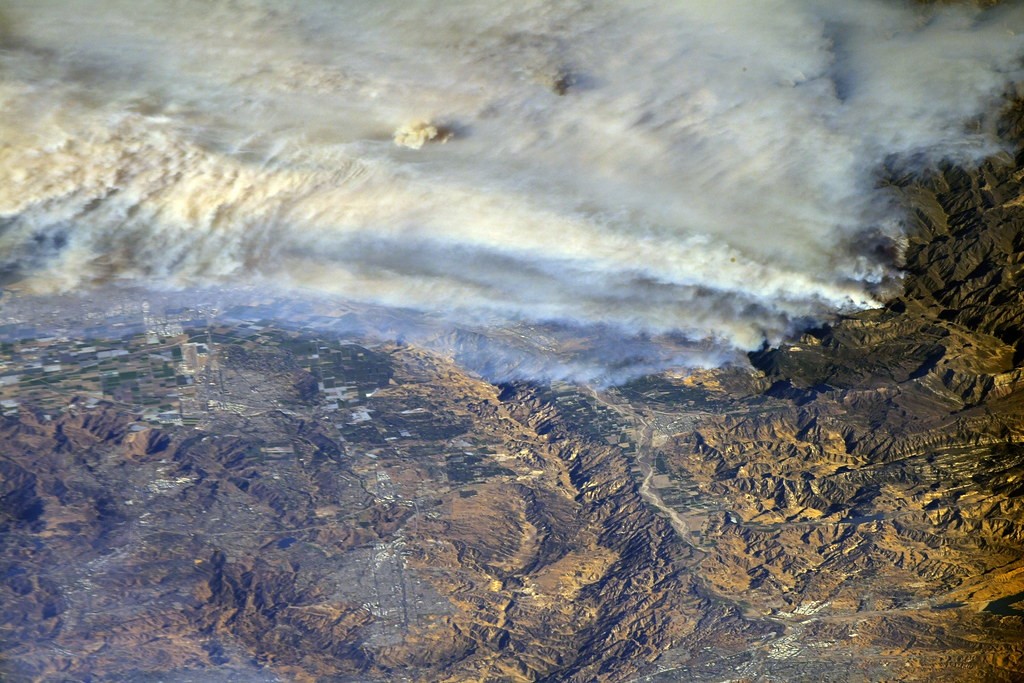
Southern California wildfires captured from the International Space Station. Image Credit: NASA Johnson
The wildland-urban interface (WUI), the area where houses and wildland vegetation mix or intermingle, is rapidly growing. Housing expansion into the WUI has increased wildfire frequency and risk. This is in part because human-caused wildfires are responsible for most of the wildfires in the WUI. The rising intensity and frequency of wildfires have led to increased damage and loss of life in recent years. Because wildfire risk increases when people live near or in the WUI, it is beneficial to study historical housing trends and urbanization in these areas.
Globally, more frequent wildfires have become the new normal, and it is important to understand if and how housing development has worsened the damage. To find answers, Neda is using historic and current high-resolution satellite imagery to map housing units in California over the past 50 years. Neda plans to evaluate housing growth from the 1970s to the present-day to evaluate if there has been a proportional increase or decrease of houses in California in the WUI.
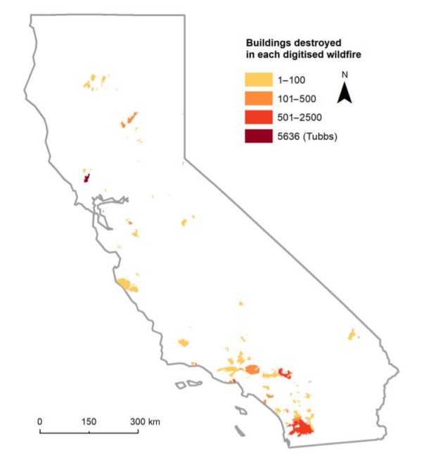
Anu Kramer (former SILVIS lab member) digitized total buildings destroyed by 89 wildfires in California from 1985-2014 and the Tubbs Fire in 2017. Figure from H.A. Kramer et al. (2019)
Neda’s main objective is to identify the areas of increased housing in the WUI and, ultimately, find out whether these areas have adapted to potential risks caused by wildfires. The main idea is to provide insight into how humans have adapted to wildfires over the past 50 years. Researching whether policy and communities adjust where houses are built based on wildfire risk could provide insight into the extent of WUI growth.
With thoughtful housing choices, there could be substantial benefits to the environment, as well as saving human lives, money, houses, and wild animals. Since it is always wise to “learn from our own mistakes,” it is important to understand which choices in the 20th century have caused additional wildfire risk. Stay tuned and follow Neda’s work for insight into thoughtful housing choices in California.
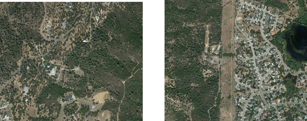
Examples of intermix (left) and interface (right) wildland-urban interface areas located near Redding, California. Photos from Google Earth.
Targeting conservation actions efficiently requires information on vulnerability of and threats to conservation
targets, but such information is rarely included in conservation plans. In the U.S., recently updated State Wildlife
Action Plans identify Conservation Opportunity Areas (COAs) selected by each state as priority areas for future
action to conserve wildlife and habitats. The question is how threatened these COAs are by habitat loss and
degradation, major threats to wildlife in the U.S. that are often caused by housing development. We compiled
spatial data on COAs across the conterminous U.S. We estimated COA vulnerability using current land protection
status and COA threat using projected housing growth derived from U.S. census data. COAs comprise 1–46% of
each region. Across regions, 28–82% of the area within COAs is vulnerable to future housing development, and
5–55% and 7–23% of that vulnerable COA area is threatened by projected dense housing and rapid housing
growth, respectively. COA vulnerability is greatest in the East. Threat from dense housing and rapid housing
growth is highest in the Northeast and Pacific Southwest, respectively. Results highlight that many areas
identified as important for reducing wildlife listings under the U.S. Endangered Species Act may need further
protection to fulfill their conservation goals because they are both vulnerable to and threatened by future
housing development. Our analyses can help practitioners target local government outreach, land protection
efforts, and landscape-scale mitigation programs to decrease future COA loss from housing development, and
could be expanded to address additional COA threats (e.g., wildfire, invasive species).
Residential development is one of the most intensive and widespread land uses in the United States, with
substantial environmental impacts, including changes in forest cover. However, the relationships between forest
cover and residential development are complex. Contemporary forest cover reflects multiple factors, including
housing density, time since development, historical land cover, and land management since development. We
investigated how forest cover varies with housing density, housing age, and household income over a range of
development intensities, in six ecoregions within New York State, Wisconsin, and Colorado. We find areas with
residential development do retain important forest resources: across landscapes they are typically more forested
than areas that remain undeveloped. However, forest cover consistently had a negative, inverse relationship with
housing density, across study areas. Relationships between forest cover and housing age and household income
were less common and often restricted to only portions of a given region, according to geographically weighted
regression analyses. A better understanding of how forest cover varies with residential development, outside of
the typically studied urban areas, will be essential to maintaining ecosystem function and services in residential
landscapes.
Globally, and in the US, wildfires pose increasing risk to people and their homes. Wildfire management
assumes that buildings burn primarily in the wildland–urban interface (WUI), where homes are either ignited directly
(especially in intermix WUI areas, where houses and wildland fuels intermingle), or via firebrands, the main threat to
buildings in the interface WUI (areas with minimal wildland fuel, yet close to dense wildland vegetation). However, even
urban areas can succumb to wildfires. We examined where wildfire damages occur among urban, rural and WUI (intermix
and interface) areas for approximately three decades in California (1985–2013). We found that interface WUI contained
50% of buildings destroyed by wildfire, whereas intermix WUI contained only 32%. The proportion of buildings destroyed
by fires among classes was similar, though highest in interface WUI areas (15.6%). Our results demonstrate that the
interface WUI is where most buildings were destroyed in California, despite less wildland fuel. Continued advancement of
models, mitigation and regulations tailored for the interface WUI, both for California and elsewhere, will complement the
prior focus on the intermix WUI.
Sparsely settled forests (SSF) are poorly studied, coupled natural and human systems involving rural communities
in forest ecosystems that are neither largely uninhabited wildland nor forests on the edges of urban areas.
We developed and applied a multidisciplinary approach to define, map, and examine changes in the spatial
extent and structure of both the landscapes and human populations of SSF in the United States. We estimated
that the SSF in the contiguous United States, which are home to only 6–7% of the population, account for over
60% of all forested land and over 30% of all land. From 1990 to 2010 SSF declined in area by 16%, changing
little overall but declining markedly in proximity to urban perimeters. A PCA ordination and cluster analysis of
the human and landscape characteristics of SSF areas revealed complex and regionally variable patterns. Very
broadly, SSF in the far northern and western states are less densely settled and more amenity driven, while the
southeastern states north through Pennsylvania and Ohio are more densely settled and more agricultural. The
socioeconomic characteristics of SSF are often quite variable at fine scales, especially in proximity to urban
areas. Our improved multidisciplinary understanding of SSF raises important questions about regional differences
in the dynamics, structure and future socioeconomic trajectories of these forests. To best manage these
landscapes for the sake of both human and natural systems, SSF need to be considered a distinct land classification
in their own right, not merely perceived as fuzzy boundaries around wild lands or urban areas.
The Wildland–Urban Interface (WUI) is the area where houses and wildland vegetation
meet or intermingle, which causes many environmental problems. The current WUI is widespread in
many regions, but it is unclear how the WUI evolved, especially in regions where both houses and
forest cover have increased. Here we compared WUI change in the Polish Carpathians for 1860 and
2013 in two study areas with different land use history. Our western study area experienced gradual
forest increase and housing growth over time, while the eastern study area was subject to a shock
due to post-war resettlements, which triggered rapid reforestation. We found that in both study
areas WUI extent increased from 1860 to 2013 (41.3 to 54.6%, and 12.2 to 33.3%, in the west and east,
respectively). However the causes of WUI growth were very different. In the western study area new
houses were the main cause for new WUI, while in the eastern study area forest cover increase was
more important. Our results highlight that regions with similar current WUI cover have evolved very
differently, and that the WUI has grown rapidly and is widespread in the Polish Carpathians.
Over the past 30 years, the cost of wildfire suppression and homes lost to wildfire in the U.S. have increased dramatically, driven in part by the expansion of the wildland-urban interface (WUI), where buildings and wildland vegetation meet. In response, the wildfire management community has devoted substantial effort to better understand where buildings and vegetation co-occur, and to establish outreach programs to reduce wildfire damage to homes. However, the extent to which the location of buildings affected by wildfire overlaps the WUI, and where and when outreach programs were established relative to wildfire, is unclear. We found that most threatened and destroyed buildings in the conterminous U.S. were within the WUI (59% and 69%, respectively), but this varied considerably among states. Fires with the greatest building loss were close to outreach programs (such as Firewise), but for 76% of destroyed buildings, the nearest outreach program was established post-wildfire. In these locations, as well as places new to the WUI or in areas where the fire regime is predicted to change, pre-emptive outreach could improve the likelihood of building survival and reduce the human and financial costs of structure loss.
Increasing residential development around protected areas is a major threat for protected areas worldwide, and
human population growth is often the most important cause. However, population is decreasing in many regions
as a result of socio-economic changes, and it is unclear how residential development around protected areas is
affected in these situations. We investigated whether decreasing human population alleviates pressures from
residential development around protected areas, using Puerto Rico—an island with declining population—as a
case study. We calculated population and housing changes from the 2000 to 2010 census around 124 protected
areas, using buffers of different sizes.We found that the number of houses around protected areas continued to
increase while population declined both around protected areas and island-wide. A total of 32,300 new houses
were constructed within only 1 km from protected areas, while population declined by 28,868 within the
same area. At the same time, 90% of protected areas showed increases in housing in the surrounding lands,
47% showed population declines, and 40% showed population increases, revealing strong spatial variations.
Our results highlight that residential development remains an important component of lands surrounding
protected areas in Puerto Rico, but the spatial variations in population and housing changes indicate that management
actions in response to housing effects may need to be individually targeted. More broadly, our findings
reinforce the awareness that residential development effects on protected areas are most likely widespread and
common in many socioeconomic and demographic settings.
Wildfires are a major threat to people and property in Wildland Urban Interface (WUI) communities
worldwide, but while the patterns of the WUI in North America, Europe and Oceania have been studied
before, this is not the case in Latin America. Our goals were to a) map WUI areas in central Argentina, and
b) assess wildfire exposure for WUI communities in relation to historic fires, with special emphasis on
large fires and estimated burn probability based on an empirical model. We mapped the WUI in the
mountains of central Argentina (810,000 ha), after digitizing the location of 276,700 buildings and
deriving vegetation maps from satellite imagery. The areas where houses and wildland vegetation
intermingle were classified as Intermix WUI (housing density > 6.17 hu/km2 and wildland vegetation
cover > 50%), and the areas where wildland vegetation abuts settlements were classified as Interface
WUI (housing density > 6.17 hu/km2, wildland vegetation cover < 50%, but within 600 m of a vegetated
patch larger than 5 km2). We generated burn probability maps based on historical fire data from 1999 to
2011; as well as from an empirical model of fire frequency. WUI areas occupied 15% of our study area and
contained 144,000 buildings (52%). Most WUI area was Intermix WUI, but most WUI buildings were in
the Interface WUI. Our findings suggest that central Argentina has a WUI fire problem. WUI areas
included most of the buildings exposed to wildfires and most of the buildings located in areas of higher
burn probability. Our findings can help focus fire management activities in areas of higher risk, and
ultimately provide support for landscape management and planning aimed at reducing wildfire risk in
WUI communities.