Posted 08/3/11
The majority of fires in the contiguous 48 United States are the result of human-caused ignitions. A team of researchers from University of Wisconsin, the Conservation Biology Institute, and the U.S. Forest Service are working to model fire occurrences in the Huron-Manistee National Forest. They compared multiple modeling approaches to identify where fires happen and which environmental factors are most strongly associated with ignitions.
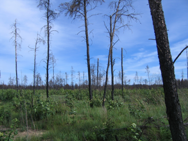
In 2010, the Meridian Boundary Fire burned over 8,500 acres in and near the Huron District of the Huron-Manistee National Forest. Like 99% of the other 340 fires that have occurred on the Huron since 1994, the Meridian Boundary Fire was human-caused. The fire destroyed 13 homes, damaged 2 others, and destroyed or damaged 46 outbuildings. There was nothing unusual or sinister about the fire. The ignition was accidental. Things simply went wrong as a resident executed a permit to burn brush.One reason why this area burns so often is that forests are dominated by Jack Pine, a native species that is extremely flammable. A second reason is that the soils are very sandy leading to rapid drying of fuels even after heavy rains. ‘Fires in this system can go crazy’, says Avi Bar Massada, a post-doctoral researcher in the SILVIS lab. ‘Burning jack pine stands can end up as raging crown fires’.
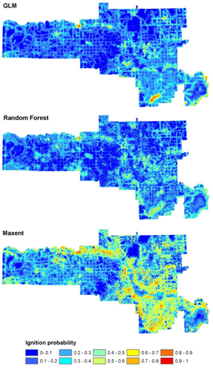
Bar Massada is part of a team of researchers seeking to predict where fires are likely to occur and which anthropogenic variables are most often associated with fire ignition.Bar Massada, Professor Volker Radeloff, and their collaborators from the Conservation Biology Institute and the U.S. Forest Service have compared multiple modeling approaches to determine which variables are most strongly correlated with fire ignition. Interestingly, Bar Massada says, ‘Fire ignitions behave pretty much the same as wildlife species occurrences.’ In fact, one of the modeling approaches he used for predicting wildfire ignitions is MaxEnt, a program that has been used to model distribution of wildlife species. MaxEnt uses known occurrences of a species (or, as in this case, a wildfire ignition event) to determine which factors best predict those occurrences. Those factors can then be used to predict future occurrence of the phenomenon of interest, such as fire ignition.
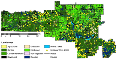
The research has shown that the best predictor of fire occurrence is distance from the nearest road, a consistently good predictor of fire occurrence in the 48 contiguous United States. Fires on the Huron NF rarely occur far from a road, because humans – rather than lightning – are causing the fires. The other three major factors that predict where a fire will ignite include distance from the nearest house, housing density in the surrounding area, and elevation.The ultimate goal is to be able to direct limited resources to preventing fires before they start, saving life and property. Accurate prediction of ignition hazard is critical to achieving it. style=”text-align:”>
“
Story by Chris Hamilton