Posted 08/3/11
Farmland abandonment is an important land use change and has a profound influence on the provision of ecosystem services. Extensive farmland abandonment occurred in Eastern Europe following the collapse of the Soviet Union in 1991, but the spatial patterns of abandonment and its drivers are not well understood. Matthias Baumann used remote sensing and statistical techniques to map abandonment in western Ukraine and to explain the main drivers of abandonment. He found that for the region as a whole, 30% of farmland was abandoned after 1991, with locally higher rates of up to 56% in certain smaller sub-regions. He also found that most abandonment occurred in the plains and areas closest to market centers and cities, opposing his initial views that abandonment would be concentrated in marginal areas in higher elevations or far from market centers. Higher rates of subsistence farming in marginal areas and more economic opportunities for young people near cities were the main drivers of abandonment, very different from other regions of the western world and even other parts of Eastern Europe.
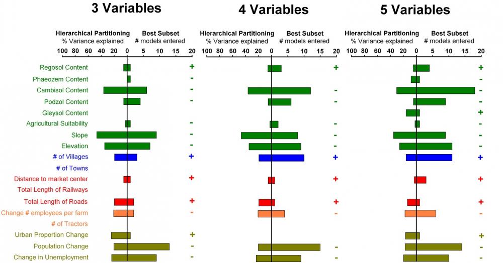
Knowing where and why farmland abandonment occurs is not only important for understanding its wide-ranging effects on human economic systems, but farmland abandonment is also very important for the provision of ecosystem services such as carbon sequestration and the provision of vital habitat for many species. After studying earlier work showing extensive areas of abandonment in small areas of post-socialist Eastern Europe post 1991, Matthias Baumann was interested to see how the political breakdown of the Soviet Union influenced both the spatial patterns and drivers of farmland abandonment over much larger areas of Eastern Europe, namely western Ukraine.To assess both the extent and possibly the drivers of farmland abandonment in the Ukraine, Matthias Baumann looked at a series of multi-temporal Landsat scenes between 1986 and 2008 for over 64,000 km2 of west and southwest Ukraine. Employing multi-date image stacks and Support Vector Machines (SVM), he mapped farmland abandonment over a variety of terrains – from areas high up in the Carpathian Mountains to the flatter plains and valleys at the base of the mountains. His results found that abandonment was widespread across the entire region, with 30% of all farmland being abandoned after 1991. The results were considerably variable by region however, with some areas showing abandonment rates as high as 56%.Using remote sensing techniques, Matthias was able to pinpoint where farmland abandonment had occurred. He then utilized statistical techniques, notably hierarchical partitioning and best subsets linear regression, to assess and determine the drivers of abandonment. The results initially surprised Matthias.
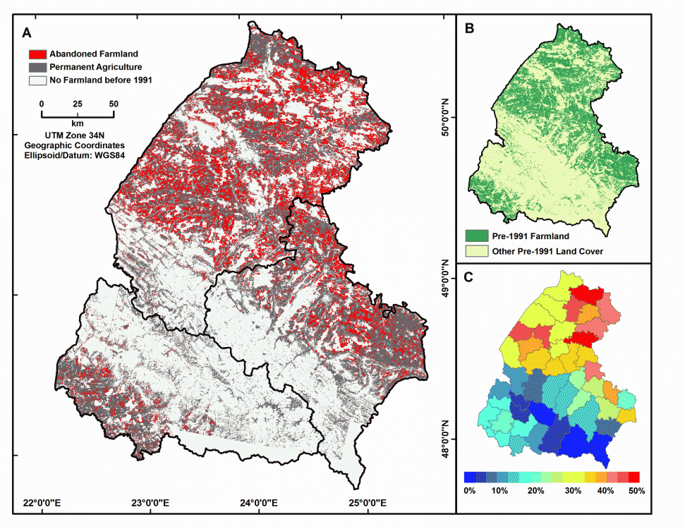
‘You would expect to see most farmland abandonment in marginal areas, such as in higher elevations, on steeper slopes, or in areas far from market centers and cities – however in Ukraine’s case, we found abandonment patterns to be the opposite’, stated Baumann. Indeed, Matthias found that in Ukraine most abandonment occurred in lower elevations, in the flatter plains, and/or closer to market centers, very different from abandonment patterns observed in Western Europe and the United States, and even in other parts of post-socialist Eastern Europe and Russia.Matthias thinks the reasons for these patterns are twofold. First, most of the farming in the higher elevations is in subsistence farming, while lower elevation and flatter area agriculture is more tied to market and social forces. Second, there are far more economic opportunities for younger people inside cities and market centers, leading to increased rates of abandonment in fertile areas close to cities as next generation farmers leave for better economic opportunities.Matthias concludes: ‘What this shows is that we have to be very careful when we try to generalize land use change and patterns of land use change because it differs significantly from the western world, and it also varies considerably within large regions that suffered the same economic shock.’ style=”text-align:”>
“
Story by Helmers, David