Posted 02/6/19
The Caucasus Mountains are experiencing both land abandonment and degradation. Katarzyna Ewa Lewinska is part of the team of scientists working to understand the underlying factors that are shaping patterns of land degradation. A complex mixture of sociopolitical factors, climate changes, and agricultural practices all seem to be contributing. Through remote sensing analysis supported by on-the-ground inspection and historical data, she hopes to identify land use changes and determine what has caused them. Land degradation has important implications for ecosystem processes, carbon sequestration, and management of natural resources.
Viewed from satellite images, the Caucasus Mountains are a mosaic of forests, rangelands and agriculture stretched across rugged topography between the Caspian and Black Seas. The political and social history in this region is long and turbulent and most recently has resulted in land abandonment. Globally, agricultural land returning to a wilder state is not a trend we are used to seeing. However, land abandonment does not always equate to thriving ecosystems.
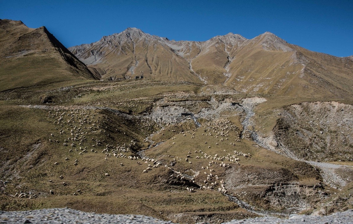
Land degradation is another important force shaping this part of the world, and often it can be traced to livestock overgrazing. In many cases, cattle or sheep are grazed near villages, rather than dispersed across the landscape. This creates a distinctive pattern that turns up in satellite imagery.
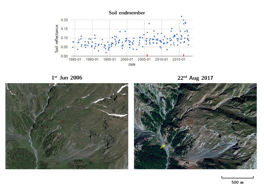
The Caucasus Mountains have been farmed intensively for thousands of years. The grasslands and forests that we see today are not in an unaltered state, but rather have changed through time in response to human pressures. Some changes happen on the ground quickly, while others are subtle and have happened over long periods of time, but in general, both can be detected with remote sensing. In the broadest sense, the goal of this research is to find those changes and determine why they are happening.
Katarzyna Ewa Lewinska (Kasia) joined the SILVIS Lab in the summer of 2018 to work with the team studying land use in the Caucasus Mountains. With a strong remote sensing background, an eye for detail, and an intense curiosity about complex problems like this one, she has already begun to make progress.
And why is it important to understand how land cover is changing and what is driving these changes? Land cover influences the ranges of many species, the health of watersheds, nutrient cycling, and the global carbon balance. Our understanding of carbon balance is limited, and carbon sequestration is not uniform across land cover types, but rather influenced by many local-scale factors including land degradation. In models, changing the way degradation is accounted for can yield results that vary by 40-200%, and so it is important to be intentional about the way degradation is defined. Besides being a complex problem, it is also a far reaching one with important implications for understanding the carbon balance and natural resources management of our planet, as 75% of land area is currently degraded and this proportion is projected to increase to 90% in the next 20 years.
Because the Caucasus Mountains are so diverse, this region is an ideal natural laboratory for understanding land use and degradation. Kasia explains the incredible variation in her study system: besides the normal degradation, the complex political and social layer, and the projected climate change, the region at its most basic level remains huge and diverse. In the northwest the climate is mild; in the southeast it’s dry and tropical. Only two of the world’s biomes are not represented here. And then there are mountains.
It is no wonder that this region has already been the focus of SILVIS Lab research. Among other projects, current postdoc He Yin and PhD student Johanna Buchner have created land use/land cover maps that track the changes occurring on this landscape every 5 years since 1987.
Kasia hopes to begin disentangling the roles of grazing and climate change in land degradation, and to become more familiar with the region’s ecology through fieldwork in the coming years. Although it’s still in the early stages, this project has a lot of momentum, and it will be interesting to see what is uncovered.
Story by Persche, Maia