Posted 08/9/10
Remote sensing data is a great resource for monitoring vegetation. However, there is limited understanding of the relationship between image texture, and ground-measured vegetation structure and patterns of bird distribution. Eric Wood is developing an approach to mapping habitat of migratory bird species in the grassland-savanna-woodland mosaic of Fort McCoy Military Installation that integrates landscape level analysis with spatially detailed habitat information, using remotely sensed image texture which is derived from unclassified imagery.
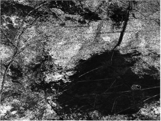
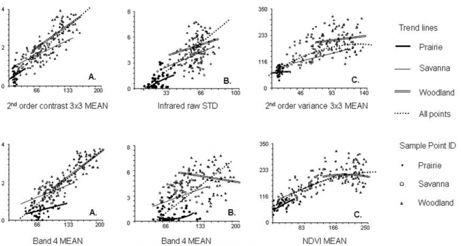
Multispectral satellite images and aerial photography can be a great source of information which can be used to help ecologists answer questions related to habitat selection in animals. An advantage of remote sensing data is that it is gathered over large areas, all at the same time, so the spectral reflectance of landcover at a particular moment in time is recorded . One measure that can be calculated from this data, called image texture, measures the heterogeneity in tonal values (i.e., digital numbers, which represent brightness) within a defined area of an image.. The heterogeneity is related to variations the amount and kind of the vegetation in the image. Eric Wood is first characterizing the relationships between image texture and vegetation structure. Once the relationships between texture and vegetation structure are understood, Wood will use image texture to build explanatory models for bird diversity and density at his study sites.Conducting his research at Fort McCoy Military Installation, Wisconsin, Eric analyzed the relationship between texture measures for each band of multispectral 30 meter resolution Landsat ETM+ images recorded in the middle of the vegetative season (July), multispectral band derivatives (Normalized Vegetation Index, which is a measure of vegetation productivity) , 1 meter resolution aerial photos, field-surveyed vegetation structure and birds species.
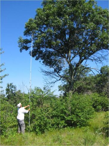
Fort McCoy, Wisconsin provided a great natural laboratory which helped Eric to investigate these questions. According to Wood, the military installation is mainly composed of three different types of the vegetation; grassland, oak savanna and oak woodland. ‘Since Fort McCoy has large areas of grassland, savanna, and woodland, which differ in their vertical vegetation profiles, as well as their bird communities, this was really the perfect location to better understand how texture can be used to monitor and map vegetation structure both within and between habitats used by birds during the breeding season’.Over three years, from 2007 to 2009 starting around the end of May till the middle of July, Eric and his team of technicians conducted vegetation and bird surveys. ‘Each day you get something different at McCoy. The grasslands are low in species diversity, but they’re home to some really special birds such as Upland Sandpipers and Dickcissels. The savannas are extremely diverse in their bird species assemblages. However, contrary to the popular thinking, it isn’t just a mix of both grassland and woodland birds. Sure, you do find grassland and woodland associated birds in the savannas. However, there is a unique and diverse community of birds which use these habitats for nesting. Furthermore, McCoy is one of the better birding spots in western Wisconsin, so I feel lucky each day I’m up at 4 am ready to head out for the day’s work.’The results of Eric’s work are encouraging. Using texture measures, primarily from aerial photos, Wood found strong relationships with vertical vegetation structure.
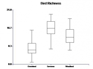
In his study area Eric also found that bird diversity didn’t increase linearly moving from grassland to savanna to woodland, but was better described by a quadratic curve, where the highest bird diversity was found in the oak savannas. ‘Savannas really are an amazing vegetation type. They were once common across the Midwestern portion of the United States. However, they’ve been nearly extirpated over the past century. Some of our results really highlight the importance of maintaining the remaining stands!’, says Eric. ‘I think remote sensing methods can be used as an important tool that complements field work, that ecologists can use to answer research questions’, concluded Eric.Eric is currently working on the analysis of the prediction of bird species richness and individual patterns of bird density with the use of image texture. He has also found that the abundance of some species is well-characterized by image texture. For example 55% of variation in Grasshopper Sparrow abundance was characterized by just one measure of image texture. One of his next efforts will be to see if image texture measures are useful in predicting the habitat of other species, such as butterflies.
“
Story by Alexander Prishchepov