Posted 07/14/10
Throughout the United States, more than 40 million houses are located in the wildland urban interface (WUI), where human settlements and natural vegetation intermingle. Avi Bar Massada is leading an effort to come up with spatial optimization tools to better allocate fuel treatments that are designated to protect houses and lives in WUI fire-prone communities. Bar Massada's team has completed developed algorithms to allocate fuel treatments, and he now applies these procedures in WUI landscapes in different parts of the United States.
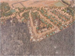
Over the past century, the desire to live closer to natural landscapes has driven many Americans out of cities and into less urbanized regions. The region of the United States where human habitation intermixes with – or is adjacent to – natural areas is defined as the Wildland Urban Interface (WUI). According to Avi Bar Massada, a post-doctoral researcher at the University of Wisconsin-Madison whose research interest in fire-human interactions was developed in his native country of Israel, ‘upwards of 40 million U.S. houses are located in the WUI with the main hot-spots for housing development in the Southeast and in the West’. Many North American vegetation types have co-evolved with fire which helps maintain ecosystem health. Thus, as Bar-Massada explains, ‘homes built in the WUI, which are near natural areas of vegetation, are more prone to harm from wildfire than urban dwellings’.The United States Forest Service has two principal approaches to protect households living in WUI areas. The first is the Home Ignition Zone approach (HIZ). Under the HIZ, home owners are encouraged to build their homes with fire proof material as well as create a 30 meter buffer around the home where trees and shrubs are removed. The second approach is based on wildland fuel treatments. Under this approach, fuel treatments are conducted around communities to decrease fuel loads, thus reducing the risk of catastrophic wildfire spreading into communities. However, Bar Massada offers that ‘although there are recommendations in place for how to fire-proof your house, there is a really limited understanding of how these guidelines and resources are actually applied across the nation. It is unlikely that millions of houses in WUI areas will comply with HIZ guidelines, because there are no regulations that force property owners to follow HIZ guidelines. I doubt it if there will be any regulations anytime soon’.Therefore, Bar Massada and his team are interested in finding optimal ways to allocate fuel treatments in the WUI to protect houses, assuming that HIZ guidelines are not always followed. ‘There has been quite a bit of research into treatment optimization in the wildlands. Yet for the WUI, where most suppression costs, time, and efforts, are concentrated, there is virtually no research on treatment optimization.’
Using satellite imagery, Geographical Information Systems (GIS), and fire simulation models, Bar Massada has developed a spatial optimization approach which allocates fuel breaks around houses in WUI areas. The motivation for this work is to find the optimal spatial configuration of fuel treatments so that overall treatment area is minimized across the landscape. The minimization guideline emerges from the chronic lack of funds for fuel treatments. ‘Forest managers have a limited amount of money to spend on fuel treatments, so the question is where you place fuel breaks across a large landscape. Essentially, we are trying to determine if it is better to spend resources to protect single houses, using vegetation removal buffers and fuel treatments, or if it is more cost-effective to combine resources and protect clusters of homes across large portions of the WUI.’ In other words, given a complex spatial configuration of houses, which houses should be treated as individuals and which as groups? Initial results from the spatial optimization procedure from a study in Northwest Wisconsin are encouraging, suggesting the computer algorithm developed by Bar Massada, and about to be published in the International Journal of Wildland Fire, is effective in determining where to place treatments in order to better protect homes. Yet Bar Massada says: ‘the prototype algorithm ignores many constrains that affect fuel treatment allocations in reality, such as ownership and costs. We will have to expand it to deal with these things to make it a practical management tool’.What are the next steps? According to Bar Massada, his team is going to work on expanding and improving his spatial optimization procedures, based on suggestions and information gathered from fire and forest managers in a WUI area in central Michigan. Eventually, Bar Massada plans to make his work available to Forest Service managers through the development of a freely available GIS extension. ‘The real goal of this research is to come up with an effective optimization procedure, and apply this to actual homes and communities in the WUI. I like the idea of this research ending up as a practical tool that managers can actually use, rather than just another scientific publication’.”
Story by Eric Wood