Posted 07/15/10
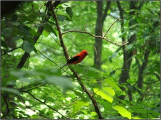
LiDAR remote sensing for ecological applications is an emerging field of study, benefiting from the sensors' ability to accurately describe the vertical structure of vegetation. In his PhD, Adrian Lesak has tested the capabilities of LiDAR remote sensing for forest inventory purposes, and its potential for quantifying the characteristics of bird populations in the deciduous forest of the Baraboo Hills, Wisconsin.
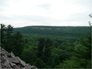
When he first started his PhD with Anna Pidgeon and Volker Radeloff, Adrian Lesak’s path to the dissertation was clear: he was to analyze the changes in the bird community between censuses conducted by Mike Mossman of the Wisconsin DNR in the late 1970’s and early 2000’s in Wisconsin’s Baraboo Hills and determine whether variation in breeding success caused by housing density and land cover may be driving those changes. Having significant field experience in bird research from his masters’ degree in Alabama, and his past work with the Forest Service in the north central Cascades of Washington, he was the perfect fit for the project. Yet, after a year at UW-Madison, Anna Pidgeon, Adrian’s advisor, ran across a news story in the local newspaper, The Sauk-Prairie Eagle. It was about a new initiative to update the flood maps for Sauk County, WI, (where the Baraboo hills are located), using airborne laser technology (LiDAR). The LiDAR survey was conducted by a Madison firm, Ayres Associates. Surprisingly, the firm was willing to share their data free of charge and even offered to increase the resolution over the Baraboo Hills, so Adrian was able to gain access to a novel and highly sophisticated data source, which had promising implications for forestry and bird studies alike.
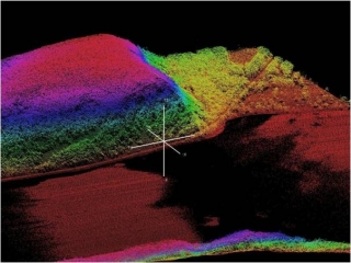
Having a new dataset to toy with, Adrian’s dissertation research was expanded to include finding new ways to quantify the characteristics of bird communities, this time from above. Using remote sensing to study birds was not necessarily a new research strategy, as aerial photos and satellite images have often been used in attempt to predict species occurrence, abundance, and richness. The underlining motive is that remote sensing approaches are always cheaper and less time consuming than field surveys. Yet, both aerial and passive satellite imagery capture only the horizontal structure of vegetation, and as such are somewhat limited in describing bird habitats. LiDAR, on the other hand, offers a wealth of information about the vertical structure of vegetation, which is known to be an important component of bird habitat.Looking to increase his skill set, Adrian jumped at the opportunity to gain expertise in a new field. Following several remote sensing courses offered at the UW, he was looking for collaborators with established expertise in LiDAR remote sensing. Anna and Volker remembered that Erik Tromborg, a former postdoc at the UW-Madison Department of Forestry, had worked with LiDAR data. Now at the Norwegian University of Life Sciences, he was happy to collaborate with Adrian, and to suggest two other prominent LiDAR scientists from Norway, Erik Naesset, and Terje Gobakken. With SILVIS alum Todd Hawbaker and Kirk Contrucci from Ayres Associates Inc. already on board contributing their invaluable expertise, the research team was formed.
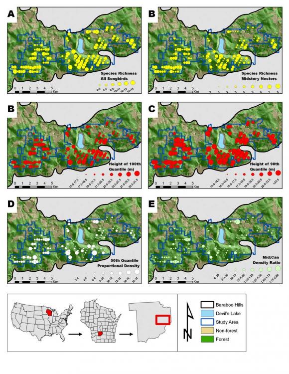
The research stemming from these collaborations focused on two major questions: How well LiDAR measurements correlate with forest structural characteristics, and can LiDAR data be used to predict bird species richness and abundance in the Baraboo hills? The first part of the research was successful, as a number of forest structure characteristics were accurately quantified from LiDAR data. This study was published in the journal Forest Science in 2010 (Hawbaker et al. 2010). The second part of the research is ongoing, but preliminary results reveal that LiDAR data is moderately effective in describing bird species richness. The predictive models are statistically significant, but their predictive power is relatively low. Adrian explains that this is actually not surprising, since the models were constructed for a single habitat type (mature deciduous forest) which has limited structural heterogeneity. As such, factors other than vertical forest structure may be contributing to local scale variations in bird species richness. He hypothesizes that when comparing different habitat types, such as different forests, the method is expected to be far more effective and that models of single species’ abundances may yield further promising results.
“
Story by Avi Bar Massada