Posted 01/28/13
Knowing where important stopover sites for migratory birds are located is crucial, because studies have shown survival rates to be lower during the migration period than either during wintering or breeding periods. David La Puma uses weather radar to locate these areas, and non-parametric regression methods to create maps of areas that are most often used by these birds. With the results of his research he hopes to provide information to land planners about areas that are high value habitat for migratory birds.
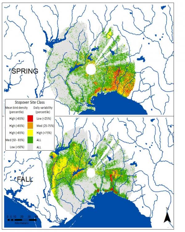
The quality and the availability of stopover habitat are crucial for the survival of migratory birds. This conclusion of research during the late 1990s formed the motivation for current the research by David La Puma and colleagues. ‘If stopover habitat is so important, then of course we want to know where it is’, La Puma says. But the task is not that easy. The majority of songbirds typically migrate under the cover of night, and when we see them making landfall in the morning they might not have found their final destination. ‘So, field-based observations and active remote sensing techniques that require daylight are not really the best option for us,’ said La Puma. He and colleagues found weather radar to be most promising source for this question because it is constantly collecting data, has a national scope with over 150 stations across the conterminous US, and most importantly it captures bird densities as they leave the landscape to initiate migration. In simple words, in the absence of water molecules in the air the return signal by the radar is the reflection of a bird. ‘What we capture in those images just after sunset are measurements of bird density from near the surface of the earth where birds took off. And if we do it multiple times over a season, which this radar network enables us to do, then we can see areas that are most favored by these birds across various time periods,’ La Puma explains. Using a large suite of explanatory factors, such as percent cover of various landcover types, canopy height and heterogeneity, and vegetative productivity, he then constructs models of bird density and habitat relationships to determine the most important factors driving stopover habitat selection.
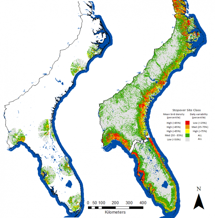
Using boosted regression trees, a non-parametric regression algorithm, allows him to consider a large number of explanatory factors and allows for even minor contributions of peripheral variables to improve model fit. Previous tests using simpler approaches did not yield the promising results he now will publish. Boosted regression trees also allow him to predict bird density across areas where radar data is unavailable, effectively ‘filling in the gaps’ between radar viewsheds. The maps generated from models help him and his research team to see the sites that are highly frequented by the birds. ‘We are now able to say which sites appear to be important for the survival of migratory birds, and therefore which ones on which to prioritize conservation efforts. But our maps also provide information about areas that are not frequented by nocturnal migrants birds, which for wind power development guidance, for example, is highly valuable information,’ La Puma points out. A few questions still remain open though. ‘We are not sure why the models provide better estimates during the fall then during the spring’, he says and assumes that hunting for more explanatory factors may help him and his research team to improve his maps. In further research, he wants to focus on what makes stopover sites unique, to deepen understanding of the interplay of migratory birds and land cover.”
Story by Matthias Baumann