Posted 01/24/13
Carlos Ramirez Reyes is developing a way to quantify forest deforestation and degradation across the entire country of Mexico. While this is a difficult task, the end result will provide a high resolution (temporal and spatial) analysis spanning 20 years. These results will then be used to inform a wide range of subsequent analyses, examining socio-economic drivers of landscape change and desertification processes.
Carlos Ramirez Reyes is working to develop a way in which remotely sensed images can be used to quantify forest degradation and deforestation in Mexico. Unfortunately the diversity of forest types that exist in Mexico makes it extremely difficult to come up with a single method that can be applied uniformly across the entire country. However this is not just an academic exercise; the products of Carlos’ efforts will provide important data that will be used together a socio-economic analysis to evaluate the success of conservation programs such as Mexico’s Payment for Ecosystem Services program, which is designed to provide incentives to reduce deforestation within the country. In addition, this data could also be used to evaluate changes in habitat suitability for different wildlife species across Mexico.
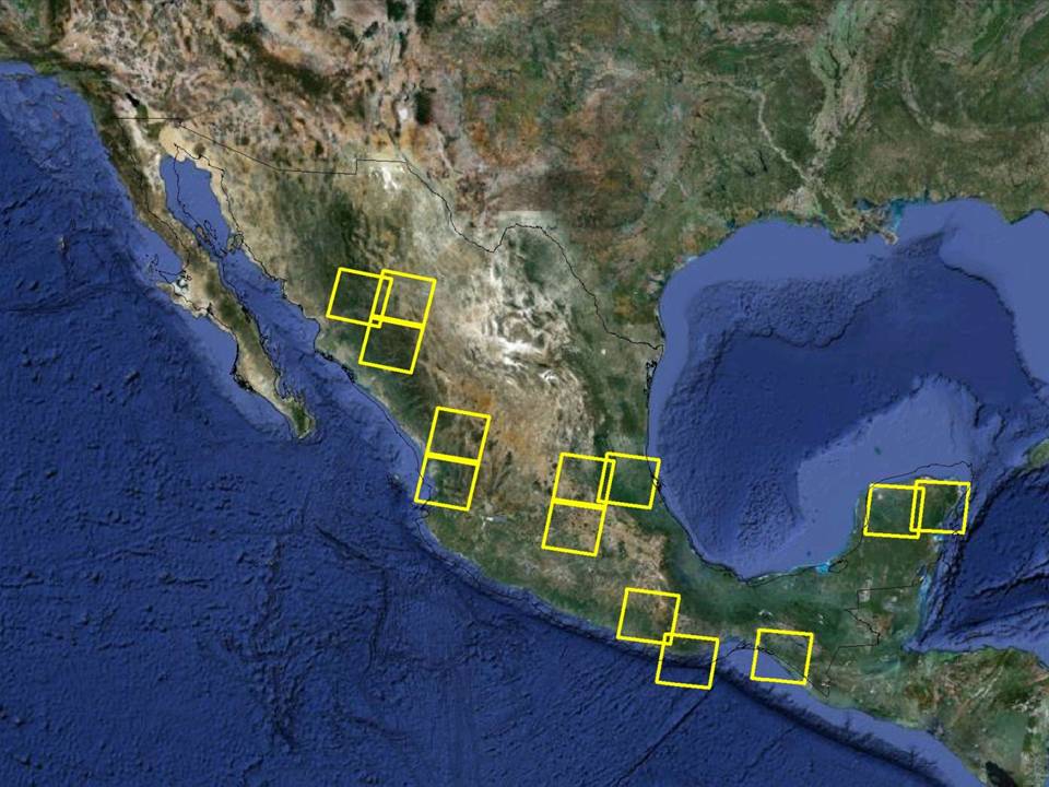
Mexico is an inherently diverse country, with a range of different ecosystems spanning different elevations and latitudes. This results in a range of different forest types, some of which look much different from a remote sensing perspective. In order to successfully automate the identification of deforestation, Carlos’ method must be able to identify the difference between forested and deforested areas in each of these different ecosystems. In order to accomplish this, Carlos is working to develop a method to examine hundreds of different Landsat satellite images in 13 regions across Mexico to accurately identify forested vs. non-forested areas. However classifying suitable images is difficult in Mexico, primarily due to the regular occurrence of cloud cover that obscures the forest. To accomplish this, Carlos is working with a team that includes Glen Aronson and Emily Duerr to rummage through countless remotely sensed images to develop a sufficient set of cloud free data that can be used to quantify and locate forest and non-forest.
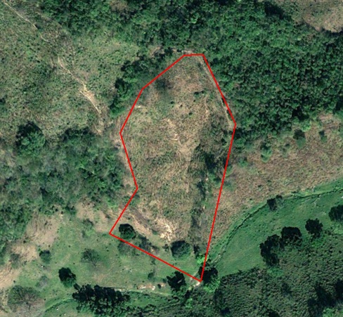
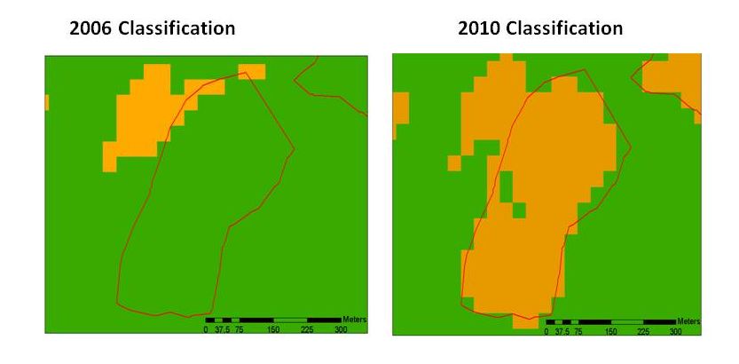
Once the images has been cloud corrected, a high performance classification algorithm will be applied to a range of satellite images covering a 20 year span from 1990 to 2010 to identify forested vs. non-forested areas across the 13 regions at temporal intervals of approximately three years. The final step will be a comparison of all the produced maps to measure deforestation trends (FIGURE 2). Also Carlos is going to perform a degradation analysis using these satellite images using spectral mixture analysis. This analysis will indicate the actual percentage of forest lost from the initial date to the end. The difference between deforestation and degradation analysis is that deforestation will detect forest cover elimination (FIGURE 3) whereas deforestation can detect partial vegetation removal (FIGURE 4). This information will be shared with collaborators (including Elizabeth Shapiro at Duke University, Jennifer Alix-Garcia at UW Madison, and Katharine Sims at Amherst College) in order to perform an evaluation of the Payments for Ecosystem Services in Mexico. This information will be also shared with Carlos’ collaborators in Mexico, which include the National Forest Commission (CONAFOR), the National Commission for Protected Areas (CONANP) and NGO Grupo Ecologico Sierra Gorda. This study is particularly important because Mexico is a benchmark for REDD programs across the world and a good way to see long term trends on forest change in Mexico.”
Story by Steve Wangen