Posted 07/15/10
In this research project, Shelley Maxted and others developed a land use monitoring approach for the National Park Service and applied this approach to two of its holdings in the Midwest: Indiana Dunes and Pictured Rocks. They found a considerable increase in development pressures between 1938 and present within and outside of Indiana Dunes National Lakeshore. While development intensity was less severe within and outside of Pictured Rocks National Lakeshore, landscape fragmentation still increased considerably.
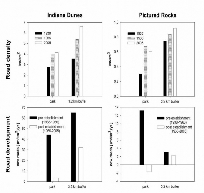
Protected areas are a major tool in conserving biodiversity and ecological services in increasingly human-dominated landscapes. However, worldwide, intensifying land use in the vicinity of national parks can limit management options inside and out. For example, housing density and road development around parks can isolate them and limit their ecological function by: fragmenting wildlife habitat, altering hydrology, spreading exotic species and polluting natural areas. Additionally, housing growth can increase property values and make it more difficult to extend park boundaries in the future. It is important that human land use in and around protected areas is carefully monitored so that its effects on their functioning can be assessed. Such monitoring should ideally be long-term, continuous, and it should be comprehensive. In this research project, a team of researchers developed a land use monitoring approach for the National Park Service and applied this approach to two of its holdings in the Midwest: Indiana Dunes and Pictured Rocks.Indiana Dunes National Lakeshore in Indiana and Pictured Rocks National Lakeshore in Michigan were chosen for their disparate locations and development pressures. Indiana Dunes is located about thirty miles from Chicago, IL while Pictured Rocks is in the remote upper peninsula of Michigan. The basic methods involved use of aerial photography and satellite imagery from three time periods – 1938, 1960 and 2005 – to quantify the change in road and building density in and around the two parks. They used geographic information system (GIS) software to digitize roads and buildings within the boundaries of the parks and within a 3.2 kilometer buffer outside of the parks. Buffers were applied to roads to account for edge effects. Changes in roads and building density and the resulting landscape fragmentation (measured as the mean land area not bisected by a road) were calculated using these data.
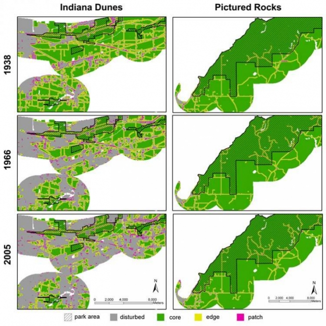
The findings from this monitoring approach were stark. Not surprisingly, development pressures around Indiana Dunes have increased considerably. Road density around Indiana Dunes has doubled since 1938 while housing density has increased from 15 buildings per square kilometer to 100 buildings per square kilometer. The mean land area within Indiana Dunes that was not bisected by a road has decreased from 0.25 square kilometers in 1938 to about 0.15 square kilometers today. Outside of the park the mean land area not bisected by a road has decreased to less than 0.1 square kilometers. Development pressures in and around Pictured Rocks have been less intense. Road density has increased only slightly from 1938 to present and housing density increased from 1 to 2 buildings per square kilometer. Landscape fragmentation declined more rapidly. The mean land area within Pictured Rocks not bisected by a road decreased from over 5 square kilometers to 3 square kilometers and outside the park decreased from about 1.5 square kilometers to 1 square kilometer.
Now that the analysis has been completed for Indiana Dunes and Pictured Rocks, efforts will shift to analyze development pressures within and outside of other parks in the Midwest, starting with Voyageurs National Park. In addition, several research extensions have come out of this work. In one study, researchers are reconstructing historical land use around Indiana Dunes and Pictured Rocks before 1938. This historical account will inform knowledge about the original ecological functions of the parks. Another study is assessing how land use changed in Indiana Dunes and Pictured Rocks in the years directly preceding and following formal designation as National Lakeshores. This work will inform understanding about how protection status influences human development pressures.”
Story by Kelly Wendland