Posted 01/16/14
Forest degradation throughout Mexico is largely a result of unregulated urban and agricultural development fueled by poverty. While the mechanisms behind the problem are well understood, it is not clear in which regions of Mexico forest degradation is greatest? PhD candidate Carlos Ramirez Reyes is exploring the use spectral mixture analysis, which is a novel method to understand within-pixel proportions of land-cover types, in order to understand this throughout biodiverse regions of Mexico.
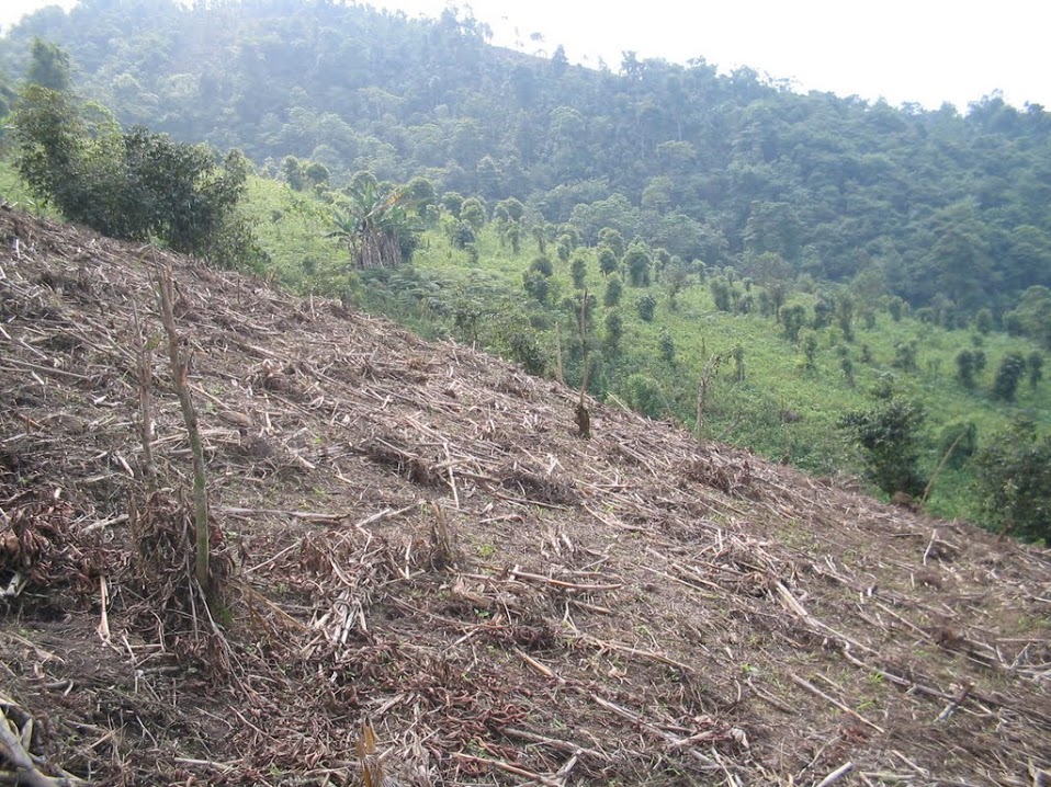
When most people think of Mexico, they imagine palm trees on the beach, possibly a cold Pacifico or margarita, a giant burrito, El Tri, and a wild spring break ending in a forgettable (or do you even remember?) night at Senor Frogs in Cancun. While he may still have these dreams when sitting at his desk, in snowy, frigid, Wisconsin, Mexican national, and PhD student Carlos Ramirez Reyes often thinks about a different type of Mexico. In addition to the fun, which Mexico has in spades, the country is also hosting a full-fledged biodiversity party. Why you ask? The answer is fairly simple. When you factor in the complex geography of the country – vast mountain ranges, coastlines of a two major water bodies, and a latitudinal gradient stretching from the mid-tropics to temperate locales – you are left with one of the most biodiverse regions on the planet. As a result, Mexico is blessed with a high diversity of natural land cover types (e.g., desert, grassland, shrubland, and forest). However, as with many developing countries throughout the world, the land cover types – in particular, the forests – are under threat. The two most common types of land cover change in forests are loss or deforestation and degradation. With loss, you have full scale clearing, which is obviously a problem for conservation. However, with degradation there is potentially a trickier problem, where portions of a forest stand are removed, or altered. Yet it is more difficult to characterize this. This is a problem because degradation can also greatly affect biodiversity.
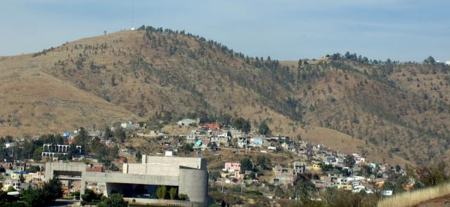
Mexico’s bountiful natural resources help support a fast growing population of 121 million people. Much of the population is centered in large urban areas, such as Mexico City and Guadalajara. Yet, outside of the city boundaries, settlement follows the pattern of aridity. In the dry north, outside of the major cities (e.g., Monterey), settlement is sparse. However, as you move south and the availability of water becomes greater, settlement is higher. In particular, poorer residents live in many rural areas outside city boundaries and rely on subsistence methods for their livelihoods. For example, forests are cleared for small dwellings and food production (e.g., corn). Such factors are a primary reason for wide-spread degradation of Mexico’s forest, which is Ramirez Reyes’ main interest. While he feels that we have a pretty good handle of the mechanisms of why forest degradation occurs, his research aims to understand the spatial and temporal extent of the problem. ‘We have little idea where in Mexico this is happening and at what rate. With so few resources available for conservation purposes, understanding this is imperative to maximize management efforts’.
To achieve a project of this scope at a country wide scale, Ramirez Reyes uses remotely sensed satellite data and a novel method, spectral mixture analysis. ‘It would be virtually impossible to achieve this study on foot. Yet, the need is urgent, so we use the best publically datasets available to get a handle of forest degradation in Mexico’. Using data from the Landsat satellite, which provides spectral reflectance data at 30-m pixel resolution, Ramirez Reyes focused his efforts across three time steps 2000-2005-2010, within three regions of the country: (1) pine/oak forests of the Sierra Madre Occidental (north-west Mexico), (2) mixed-forests of the Sierra Madre Oriental (north-east Mexico), and (3) tropical deciduous forests of the Yucatan Peninsula. He chose these areas because they are high in forest cover, yet different in forest types, and also are along a gradient of settlement (1-3, low to high). To detect forest degradation, Ramirez Reyes used a novel method, spectral mixture analysis, which is used to understand within-pixel proportions of land-cover types. Thus, over the three time steps, Ramirez Reyes will be able to understand if forest cover in a particular pixel was preserved, degraded, or lost, over time. ‘This method is quite novel because Landsat data provides information at a fairly fine-resolution, yet, there are often multiple land-cover types within a 30-m pixel. Thus, we needed a better way to classify the amount of forest change at an even finer resolution than the raw Landsat data. Using spectral mixture analysis allowed us to do just this.’ So far Ramirez Reyes found that in the north-western pine/oak forests of the Sierra Madre Occidental, forest degradation was low. ‘Really, there are not many people living outside cities or ranches in this region, and thus we noticed quite a lot of intact forest’. This is good news for a region’s forest, which helps support many species of plants and wildlife. On the other hand, in the Sierra Madre Oriental and Yucatan Peninsula, forest degradation could be much higher. ‘In the Sierra Madre Oriental, we noticed quite a lot of degradation. Additionally, the pressure was nearly as intense in the tropical forests of the Yucatan Peninsula, but the mechanism was likely different. ‘Here, we think much of the forest degradation is due to tourism development. All along the coast, major resorts are sprouting up, and when you have these resorts, you need the infrastructure and resources to create them. The surrounding forests are likely strongly affected by all of this and also the need for livestock and agriculture for the new developments’. What is next for Ramirez Reyes and his research? ‘We need to distribute this information to government officials, managers, and NGOs, which can hopefully come together to find solutions for the problems we found in the Sierra Madre Oriental and Yucatan Peninsula. We strongly feel that without this information, there is unlikely to be action to address the problems’.”
Story by Eric Wood