Posted 01/28/21
Climate change is rapidly altering winter conditions across the mid to high latitudes. Winter is a critical season for many plants and animals: cold temperatures and snow cover strongly influence species distributions, population-level movements, and individual survival. To help better understand the relationship between winter conditions and biodiversity patterns, SILVIS researchers David Gudex-Cross and Likai Zhu have derived new satellite-based indices of snow and frozen ground dynamics for the US and the globe.
Given the rapid rate of climatic change occurring during the winter months, particularly in the Northern Hemisphere, researchers are working diligently to assess the potential effects of these changes on biodiversity assessments and conservation planning. A major hindrance to these efforts to date has been a lack of remotely sensed indices that characterize winter conditions for ecological questions across large spatiotemporal scales. David and Likai are addressing this need by leveraging the wealth of available satellite data to derive new indices of snow and frozen ground dynamics. These Winter Habitat Indices (WHIs) capture several biologically important aspects of winter, including overall length, within-season climate variability, and potential subnivium conditions.
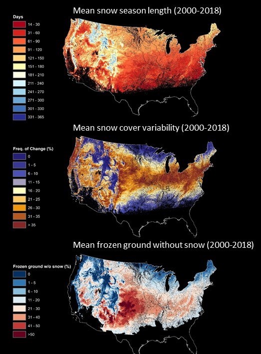
To date, David has developed three WHIS for the contiguous US using MODIS snow observations and temperature data from Daymet at 500-meter spatial resolution: snow season length, snow cover variability, and the frequency of frozen ground without snow days. First, snow season length is the total number of days between the first and last snow in a given year (a measure of overall winter length). Second, snow cover variability captures the frequency with which a pixel is snow covered then not (ablation) or vice versa (new snow) within a given snow season. This index is especially important for species that rely on white coloration during the winter for camouflage, such as snowshoe hares, because it enables the identification of potential mismatch periods (i.e., when an individual is in its white color morph but there is no snow). Third, the frequency of frozen ground without snow days approximates subnivium conditions, with higher frequencies meaning organisms faced harmful freezing conditions without the thermal refugia provided by snow more often in a given year.
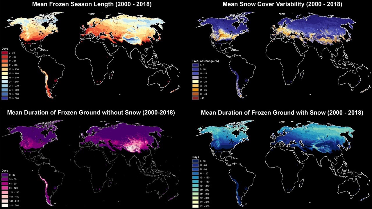
Using MODIS snow observations and freeze/thaw data from microwave sensors, Likai previously developed three WHIs globally at a 25-kilometer spatial resolution: duration of frozen ground, frozen ground with snow, and frozen ground without snow. Now he has also derived the snow cover variability index mentioned across the globe. The duration of frozen ground is arguably one of the most biologically appropriate definitions of winter length, especially for vegetation. The duration of frozen ground with and without snow indices are again approximating subnivium conditions, which provide critical insulation against freezing temperatures for soil organisms, plants, and animals.
To assess the potential of the WHIs for ecological research and predicting biodiversity patterns, David is working with collaborators at UW (Ben Zuckerberg, Jon Pauli, and Spencer Keyser) and the Cornell Lab of Ornithology (Daniel Fink) to model relationships between the WHIs and species richness for birds estimated from eBird data. The results have been promising: all of the WHIs have shown strong relationships with species richness patterns for birds across the US. Expectedly, measures of winter length (i.e., snow season length and duration of frozen ground) have a negative relationship with species richness across all taxa: areas with long winters have fewer species relative to those with shorter winters. The snow cover variability and frozen ground without snow indices, on the other hand, have more complex, nonlinear relationships with bird species richness. Generally, snow cover variability has had a positive relationship with species richness: areas with higher snow cover variability have more bird species than those with lower variability.
These results highlight the great potential and promise of the WHIs for ecological research, biodiversity assessments, and conservation planning. David and Likai continue to derive the WHIs from new datasets in hopes of maximizing the spatial and temporal resolutions available to researchers, with the latest being the 30-meter harmonized Landsat 8-Sentinel 2 dataset. Given the rapid rate of winter climate change, they hope others will utilize the WHIs in their winter ecology studies and species distribution models to inform conservation strategies moving forward.
Story by Gudex-Cross, David