![](https://russell-silvis.dev.webhosting.cals.wisc.edu/wp-content/uploads/sites/231/2019/01/rmap_nrs8_small-600x200.jpg)
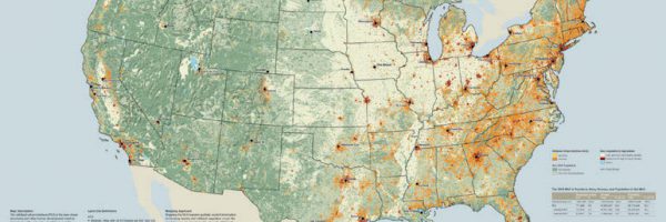
BLOCK LEVEL HOUSING DENSITY
Growth in Housing Density in the U.S. between 1990 and 2010
![](https://russell-silvis.dev.webhosting.cals.wisc.edu/wp-content/uploads/sites/231/2019/01/United_States_blk_pla_2010_black-600x200.gif)
![](https://russell-silvis.dev.webhosting.cals.wisc.edu/wp-content/uploads/sites/231/2019/01/DHI-600x200.png)
![](https://russell-silvis.dev.webhosting.cals.wisc.edu/wp-content/uploads/sites/231/2020/01/DHI_clusters_1080p-600x200.gif)
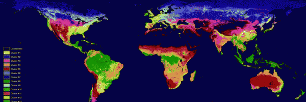
Global Subnivium Data
Snow Cover & Snow Free Duration
Start/End/Length of Frozen Season
![](https://russell-silvis.dev.webhosting.cals.wisc.edu/wp-content/uploads/sites/231/2019/10/FreezeThawMap-600x200.jpg)
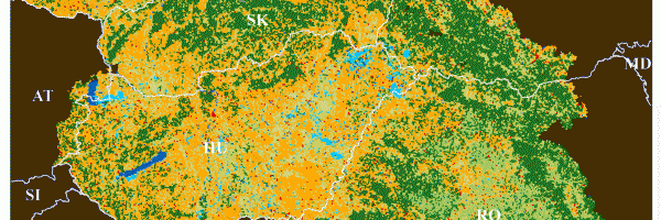
Historical Land Use in the Carpathians
Land use change in the Carpathians between 1860 and 1960
![](https://russell-silvis.dev.webhosting.cals.wisc.edu/wp-content/uploads/sites/231/2019/01/1860_map_carp-600x200.gif)
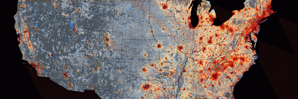
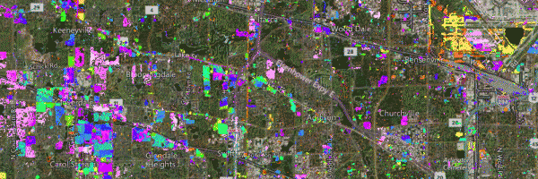
Impervious/Tree Cover Change around Chicago
Magnitude/Timing of Imperviousness and Tree Cover Change
![](https://russell-silvis.dev.webhosting.cals.wisc.edu/wp-content/uploads/sites/231/2019/01/chicago_imperv_front-600x200.gif)
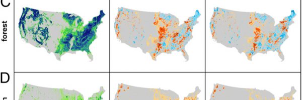
U.S. Future Land Cover Projections
Scenarios of Future U.S. Land Cover in 2050
![](https://russell-silvis.dev.webhosting.cals.wisc.edu/wp-content/uploads/sites/231/2019/01/Lawler_etal_2014_PNAS_0-600x200.jpg)
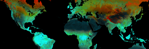
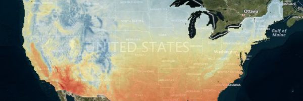
Climate Averages and Extremes
Historic/Modeled Climate Data for Conterminous U.S.
![](https://russell-silvis.dev.webhosting.cals.wisc.edu/wp-content/uploads/sites/231/2019/01/climate_map-600x200.jpg)
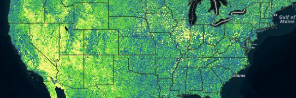
Habitat Heterogeneity Texture Metrics
EVI Peak Greenness and 1st/2nd order texture metrics
![](https://russell-silvis.dev.webhosting.cals.wisc.edu/wp-content/uploads/sites/231/2020/01/Texture_Metrics-600x200.jpg)
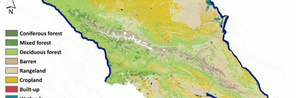
Caucasus Land Cover Change
Land-cover and forest/cropland change maps of the Caucasus
![](https://russell-silvis.dev.webhosting.cals.wisc.edu/wp-content/uploads/sites/231/2020/02/Caucasus_LC_2015-600x200.gif)
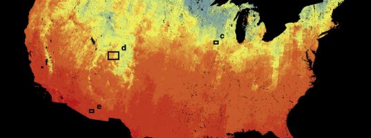
TIRS-Derived Biodiversity Patterns
Landsat 8 TIRS-derived thermal variables to predict winter biodiversity patterns
![](https://russell-silvis.dev.webhosting.cals.wisc.edu/wp-content/uploads/sites/231/2020/05/ElsenThermalWebMap-537x200.jpg)
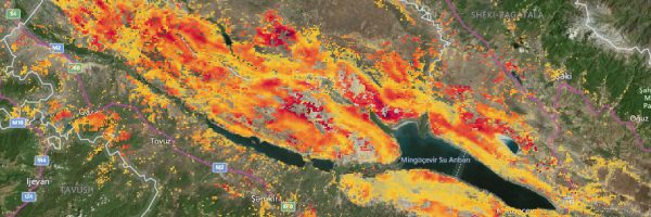
Vegetation loss in Caucasus grasslands
Vegetation loss in grasslands in the Caucasus 2002-2018
![](https://russell-silvis.dev.webhosting.cals.wisc.edu/wp-content/uploads/sites/231/2020/07/CaucususGrasslandZoom-600x200.jpg)
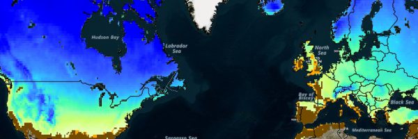
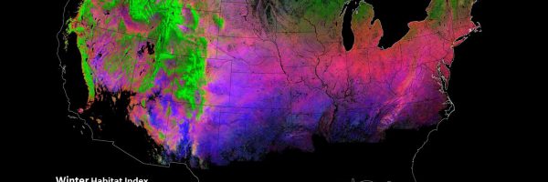
Winter Habitat Indices (WHIs)
WHIs based on Snow Cover Variability, Snow Season Length, and Frozen Ground without Snow duration.
![](https://russell-silvis.dev.webhosting.cals.wisc.edu/wp-content/uploads/sites/231/2021/01/DGCfront-600x200.jpg)
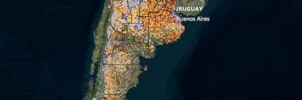
Spatial and Temporal Variability Indices for Argentina
Vegetation greenness, land surface temperature, and hotspots of conservation concern
![](https://russell-silvis.dev.webhosting.cals.wisc.edu/wp-content/uploads/sites/231/2021/03/argentina1-600x200.jpg)