Aug 2010
- Conservation
- Remote Sensing
Alexander Prishchepov is looking at region in Eastern Europe that allows constructing and testing hypothesis about land use changes in a transition from command to market economy.
Aug 2010
- Fire
- Remote Sensing
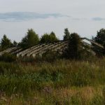
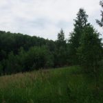
Grassland fires in Kalmykia, Russia increased dramatically following the collapse of socialism. Socio-economic changes reduced livestock numbers and therefore grazing pressure on grasslands. Maxim Dubinin analyzed over 20 years of satellite images to quantify this change.
Aug 2010
- Conservation
- Remote Sensing
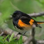
Vegetation structure is an important habitat attribute characterizing bird habitat. Measuring vegetation structure in the field is time consuming and thus inefficient across large scales. Eric Wood is exploring whether use of a metric called image texture derived from satellite and aerial images can potentially streamline the process of assessing vegetation structure and facilitate prediction of bird distribution across large areas.
Jul 2010
- Biodiversity
- Birds
- Remote Sensing
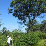
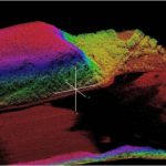
A 2005 news item in The Sauk Prairie Eagle prompted Adrian Lesak to dive right into the emerging field of laser remote sensing for forestry and biodiversity applications while forming an international research collaboration.
Jul 2010
- Remote Sensing
Social and economic changes occurring in post-socialist Russia have led to shifting patterns of selective logging in the understudied temperate forests of Russia, potentially leading to poor estimates of carbon stocks across this vast region. Matthias Baumann hopes to describe these patterns of forest cover change and refine methods for remotely sensing selective logging and determining it’s impacts on carbon stock estimates for these forests.
Jul 2010
- Biodiversity
- Conservation
- Remote Sensing
Can a bumper sticker inspire innovative research? In the case of Chad Rittenhouse PhD, a chance sighting motivated an innovative line of research that questions how changes occur in the natural world and how we perceive and measure these changes.
Mar 2010
- Land Use
- Remote Sensing
Last fall, Jodi Brandt started a new, exciting project studying intertwined networks of human-natural relationships in NW Yunnan, China. Jodi will primarily use high-tech remote sensing and geographic information system approaches to uncover some of the mysteries of her study region.
Jan 2010
- Remote Sensing
Chain Classification is a new methodology to map landcover for large areas. The basic idea is to extrapolate the information obtained in one classified image (first) to classify an adjacent image (second). A third image can be classified based on the second and so on, resulting in a Chain classification.
Jan 2010
- Land Use
- Remote Sensing
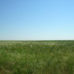
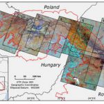
With an increasing human population and expanding impact on the environment, extinctions are happening at an unprecedented pace. So what would happen if people suddenly left the land and let it return to a natural state. Well, just such a scenario is playing out in Eastern Europe following the collapse of the former U.S.S.R..