University of Wisconsin–Madison
SILVIS LAB
Spatial Analysis For Conservation and Sustainability
  • HOME
  • PEOPLE Expand Collapse
    • Current Members
    • Alumni
  • RESEARCH Expand Collapse
    • Overview
    • Biodiversity
    • Birds
    • Conservation
    • Fire
    • Houses & WUI
    • Land Use
    • Remote Sensing
  • PUBLICATIONS
  • MAPS & DATA Expand Collapse
    • Wildland-Urban Interface (WUI) Change 1990-2010
    • Block Level Housing Density Change 1990-2010
    • Dynamic Habitat Indices
    • Climate Averages and Extremes Data
    • Argentina Spatial and Temporal Variability Indices
    • Many more…
  • IN THE NEWS
  • ABOUT US Expand Collapse
    • Information for prospective graduate students, postdocs, and visiting scholars
    • Facilities and Equipment
  • Sign In

Biodiversity

Species richness varies by orders of magnitude across the globe and so does the richness of endangered species. We are interested in both the macroecological processes causing richness patterns, and the socioeconomic processes determining where biodiversity is threatened.

After the fall: Land cover mapping in the Caucasus

Jan 2019 - Biodiversity - Land Use - Remote Sensing

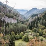
What happens to croplands/forests during political instability? Johanna Buchner’s work in the Caucasus shows that change is dependent on local conditions, and not similar across broad scales.

Steller’s Jay that has been fitted with a radio-transmitter to track its movements and has been banded with a unique color combination, so it can be identified in the future without having to be re-captured.

Steller’s Jay and Marbled Murrelet management

Dec 2018 - Biodiversity - Birds - Conservation

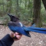
Kristin Brunk is conducting research to determine if management of one bird species can conserve the other in California.

Map of habitat heterogeneity across the conterminous U.S., based on 30-m resolution standard deviation texture (21x21 moving window) of NDVI (index of vegetation greenness) from Landsat 8 imagery. Darker green areas indicate regions with higher habitat heterogeneity.

Characterizing habitat heterogeneity using image texture

Dec 2018 - Biodiversity - Birds - Conservation - Remote Sensing

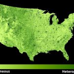
Laura Farwell is using image texture measures as powerful predictors of regional and global biodiversity patterns.

Moose abundance in the former Soviet Union can be predicted from the DHI Photo source: pexels.com

Predicting Moose Abundance from Space

Dec 2018 - Biodiversity - Conservation - Remote Sensing

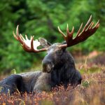
Elena Razenkova found that remote measures of productivity like DHI can help explain moose abundance over the last 3 decades.

  • Previous page
  • 1
  • 2
  • 3
  • You're on page 4
  • 5
  • 6
  • 15
  • Next page
University logo that links to main university website

Contact Us

  • Dept of Forest & Wildlife Ecology
    Russell Laboratories
    1630 Linden Drive
    Madison, WI 53706
  • Map map marker
  • Email: helmers@wisc.edu
  • Phone: (608) 890-3160

Website feedback, questions or accessibility issues: helmers@wisc.edu.

This site was built using the UW Theme. © 2025 Board of Regents of the University of Wisconsin System.

Login Request Help Help Docs