Posted 01/1/15
Wildfires are a major threat to houses and people in the US. A study lead by Patricia Alexander is trying to identify the factors that determine the likelihood of house loss given a wildfire. Preliminary results show that the likelihood of a house to burn depends on multiple environmental variables, and that the spatial arrangement of houses matters.
Wildfires are a major threat to houses and people in the US. About 2 billion dollars are spent every year in preventing and suppressing fires by the US Forest Service alone, and about 1,300 houses are burned each year on average. Housing is expanding every year and the number and frequency of wildfires in increasing as well, suggesting that this problem is likely to get worse in the future. Understanding the how wildfires affect houses, and what we can do to prevent those damages, is key to guide land-use planning and management efforts in fire prone places.


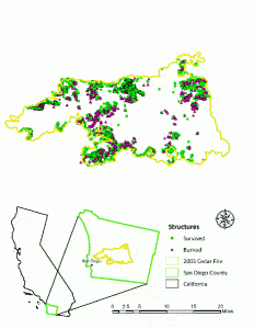
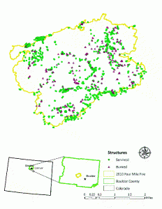
“People want nice views and to live out in the country, however, houses in such locations are under high risk of wildfires”, said Patricia Alexandre, a PhD student at Silvis. Understanding the factors that explain the likelihood of a house to burn during a wildfire is of major need for land-use planning in wildfire prone areas, and for agencies such as the US Forest Service. However, there is little knowledge on this topic according to Patricia. Patricia’s research focuses on identifying the key factors that explain the likelihood of a house to burn during a fire. For this, she is using two wildfires as case studies, including a wildfire that occurred in San Diego (California) and one in Boulder (Colorado). High resolution imagery before and after the fire is being used to map all the houses within those fires, that burned due to the fires. ‘In the Boulder fire for example, we mapped about 1100 houses, and we see that 10% of them were burned after the fire’, Patricia said.
The study explores about 40 environmental variables to predict the likelihood of a house to burn, such as vegetation conditions, topography (aspects, slope, elevation, topographic position), and the spatial arrangement of house (housing density, distance to near house). According to Patricia, predicting the likely of a house to burn is a complex task. “In Colorado, the houses most likely to burn were those on high slopes or on top of ridges, as well as those located at the edges of the neighborhoods. In San Diego, however, the results were more variable. What might explain things in one fire may not work in other.”
Another important finding from this study is that the spatial arrangement of the houses matters. According to Patricia, “previous efforts used only topography and spatial arrangement to predict the likelihood of a house to burn given a wildfire, but we decided to add vegetation to see how much in fact is vegetation contributing to this phenomenon. We see that vegetation alone cannot explain why a house burned alone, the way houses are arranged on the land is also important”. Currents efforts are focused towards refining the models so to have a better understanding of the local forces that result in burned houses within a single fire. However, the ultimate goal is to expand the study to the whole US.Patricia hopes that this study will help the government to allocate resources (e.g. fuel management) in a more efficient manner, and will provide land-use planners, urban planners, and home owners with useful information and recommendations about housing construction in wildfire-prone areas. This study is a step towards Patricia’s dissertation focused on understanding the factors that explain house loss to wildlife in the US. “My ultimate goal is to develop a risk map for the whole US that tells you how likely it is that your house burns if a fire occurs”, Patricia said.
Story by Martinuzzi, Sebastian
